Before you drive: the road, the mountain, and consideration
The Wilderness Road is not just a tourist road. It goes through reindeer grazing land, past Sámi cultural environments, over alpine tundra, and along waters that have governed life, work, and travel routes for centuries. It is best when you drive slowly, stop with discernment, and let the landscape take its place.
The mountain stretch over Stekenjokk is normally open between June 6 and October 15. During early summer, snowbanks can be high at the roadside and the weather can change quickly. There are also special rules for stops and parking at Stekenjokk during sensitive periods, particularly with regard to reindeer and birdlife. Read signs on site and check current information before departure.
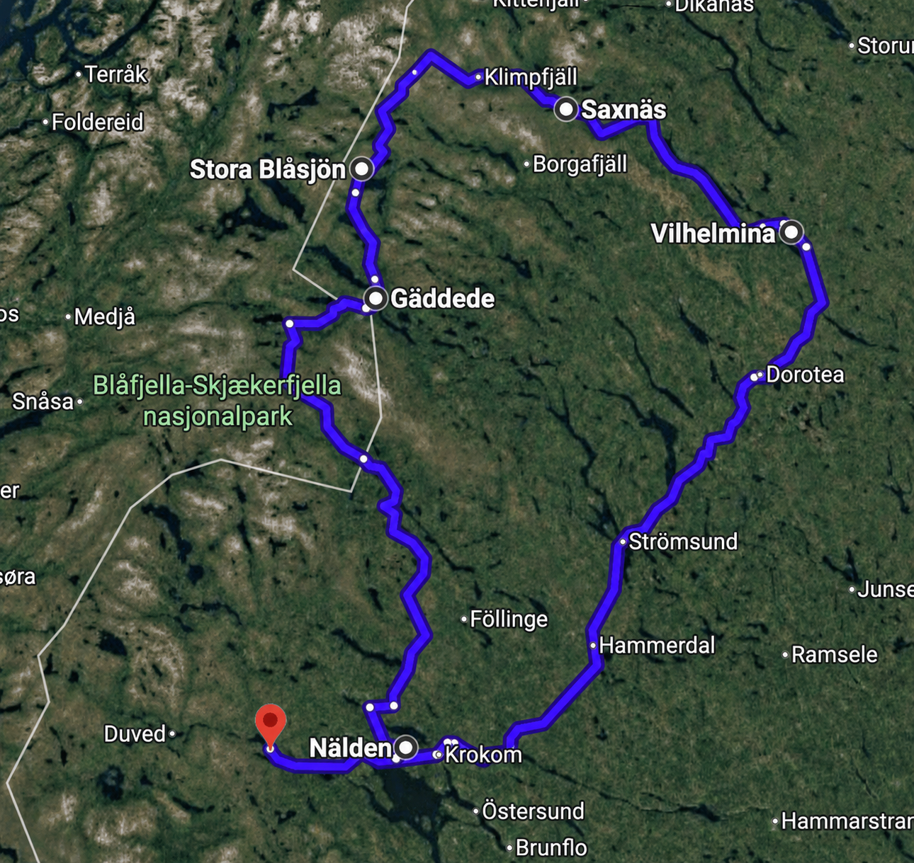
Day 1 – Tuesday: Järpen to Dalasjö/Vilhelmina
Red stageThe first day is a transport day, but it doesn't have to feel like transport. From Järpen, you roll out of the mountain edge, east through Jämtland, towards the vast coniferous forest belt of the inland. It's a gradual shift: from the open horizons of Åredalen to lakes, marshes, and roads that become straighter and more rural. After Östersund, the journey begins to take on that special inland character: long distances, small towns, and a landscape where water is almost always nearby.
Krokom and Östersund – refuel before the inland
Krokom is a good first stretch, but Östersund is the practical point: lunch, refueling, store, pharmacy, and all those things that are nice to have arranged before the journey goes north. From there, you follow the larger inland roads towards Strömsund and Dorotea.
Strömsund and Ströms Vattudal
Strömsund is the gateway to Frostviken and the Wilderness Road from the Jämtland side. The lake Ströms Vattudal lies like a long, sparkling ribbon through the village. Feel free to stop by the water if there is time. It’s a good place to sense the shift from 'traveling to the mountains' to 'traveling through the inland.'
Dorotea – short break in a small inland junction
Dorotea works well as the last stop before Vilhelmina. The town is located by the E45 and has long been a typical inland junction: not grand in a tourist brochure sense, but useful, human, and well-placed when the distances start to be felt.
Vilhelmina church town – old alleys, low wooden houses, and the distances of the Lapland
Vilhelmina church town is a nice stop before you continue to Dalasjö. The church towns in northern Sweden arose from distances. People had far to the church and needed simple overnight houses when they came for church weekends, courts, markets, and meetings. In Vilhelmina, there is still that special feeling of small alleys, low wooden houses, and a dense settlement that is not built for city life in the modern sense, but for recurring gatherings.
Vilhelmina museum is located in the old parish house from the 1890s, and the collections tell about the municipality's history from ancient times to the present. Among other things, there are items from the pioneer era's self-sufficiency and Sámi artifacts. The museum also mentions the Maksjö find, a grave find from the 700s, and a ski from the 300s – reminders that the inland was not 'empty' before roads, sawmills, and new settlements.
Day 2 – Wednesday: Dalasjö to Saxnäs
Green stageThis is the day when the landscape begins to rise. From Dalasjö and Vilhelmina, the road turns west. The lakes become longer, the valleys narrower, and the mountains come in as blue-gray layers in the background. It is one of the journey's most beautiful transitions: from forest land to mountain edge.
Malgomaj and the road westward
After Vilhelmina, you follow the water systems westward. Malgomaj is one of those lakes that makes the road feel slower than it is: water on one side, forest on the other, and sudden openings where the mountains appear in the distance. Stop when it feels right, especially if the light is low or the clouds lie in layers over the water.
Stalon – viewpoint break in Kultsjödalen
Stalon is more of a feeling than a sight: a place where the road has already begun to think mountains. From here, it is close to Kultsjödalen and Saxnäs. If you want a simple break, look for a safe place to stop where the road and the view interact. It is often here that the journey gets its first clear 'now we have arrived in the mountain world' feeling.
Trappstegsforsen – water in steps
Trappstegsforsen is almost too pedagogically named: the water falls over wide, dark stone shelves like a series of steps. The rapids are easily accessible along Vildmarksvägen and are one of those stops that work even when you are a bit tired: short walk, big effect. In the right light, the contrast between white water, black stone, and green forest becomes almost graphic.
The place has also become known as one of the most beautiful rest areas along the road. Here, there is often the opportunity for coffee, ice cream, simple food, and souvenirs in the summer, but check the opening hours if you expect service.
Saxnäs, Kultsjön, and Marsfjällen – evening by the mountain lake
Saxnäs is located by Kultsjön, south of Marsfjällen. It is one of the most scenic locations on the journey: the lake as a shiny surface in the valley, the mountains as a wall to the west, and small-scale buildings that do not take over the landscape. The evening here can become one of the highlights of the trip. Walk down to the water, let your gaze follow the length of the lake, and wait for how the colors change. Marsfjällen has a way of looking further away than they are.
Day 3 – Thursday: Saxnäs to Stora Blåsjön
Yellow/orange stageThis is the big mountain day of the journey. It starts gently at Kultsjön but soon becomes more dramatic: church town, mountain village, mining history, alpine tundra, and waterfalls. Drive with margin. It is on this day that one can easily 'just stop for a minute' and end up staying for half an hour.
Fatmomakke – a living church town, not an outdoor museum
Fatmomakke is one of the most important stops on the journey. The cultural reserve is located by Ransarån and Fatmomakeviken a few miles north of Saxnäs. The place has been used as a church site by Sámi and settlers since the late 18th century and is still in use. It is not just a collection of old buildings, but a place where generations have met for worship, trade, conversation, family ties, and celebrations.
What is special about Fatmomakke is the mix of building traditions. Here, Sámi tents and settlers' timber church cabins stand side by side. The County Administrative Board describes the place as the most prominent Sámi church town in the country and emphasizes its significance as a spiritual and multicultural meeting place in the interior. This makes Fatmomakke a place where one should walk slowly. Notice the distances between the buildings, the materials, how cabins and tents are situated in the terrain, and how the water connects the place.
Klimpfjäll – the village before the mountain plateau
Klimpfjäll is situated like a threshold between the valley and the high mountains. Here it is evident that the road was once not primarily intended as a tourist road. The Stekenjokk road was built in connection with mining plans and transport. When the Stekenjokk mine opened in 1976, the community grew; the mine was Sweden's highest located mine and operated until 1988. After its closure, the road remained, and the industrial infrastructure gradually transformed into one of the country's most famous tourist roads.
It is a good place to stop for a snack or service before you continue over the plateau. After Klimpfjäll, the landscape becomes more open and the weather more pronounced.
Stekenjokk – the road over the mountain plateau
Stekenjokk is the center of the journey's mountain plateau. The road rises above the tree line and the landscape becomes more barren, brighter, and more exposed. There are days when the plateau feels almost arctic: low vegetation, patches of snow, wind, water, and soft mountain forms. Other days it is mild and blooming, with reindeer moving across the road and cloud shadows drifting over the slopes.
It is also a sensitive landscape. The Wilderness Road goes through reindeer grazing land and parts of the area are subject to bird protection. During certain periods, you are not allowed to stop or park on certain stretches, and there are designated parking areas. If you see reindeer, keep your distance and let them move away in peace. Do not photograph by getting closer.
Stekenjokk is not a viewpoint you own just because you have a car. It is a working cultural landscape, a bird landscape, and a weather landscape.
Gaustafallet – slate, water, and a narrow passage
Gaustafallet is located near the road north of Stora Blåsjön and just a few kilometers from the Norwegian border. It is an easy stop with great drama. The water in Gaustejokk has worked its way down into the mountain and created a narrower, darker passage where the fall gains power. The municipality's visitor information mentions that with luck, you can see nesting falcons at the cliff wall.
Here it is worth listening, not just looking. After the mountain plateau's open wind, the fall takes on a different sound: concentrated, confined, almost metallic against the slate.
Stora Blåsjön – mining struggle, lake landscape, and evening calm
Stora Blåsjön is more than a beautiful name. Here lies a dramatic piece of rural history. When the mining plans and road construction were threatened by economic objections in 1971, 18 men from Stora Blåsjön went on hunger strike for nine days. The strike became nationally known and contributed to the state granting funding for the road. It is a strong reminder that roads in the interior are not just about vacations – they have often been matters of survival, work, and hope for the future.
As a place to stay overnight, Stora Blåsjön has a nice location after the mountain passage. The evening can be spent simply: a walk, a look over the water, perhaps a trip towards Ankarede if you don't save it for the next day.
Day 4 – Friday: Stora Blåsjön to Hotagen via Norway
Purple stageThis day’s route does something that feels very right for the area: it cares less about national borders than about the valleys, lakes, and old travel routes. You drive from Frostviken towards Gäddede, veer into Norway through Lierne, and return to Sweden at Valsjöbyn before reaching Hotagen. It is a borderland day, and it is evident in both names, landscapes, and history.
Ankarede – church town at the meeting of two rivers
Ankarede is located at the mouth of the Ankar River and the Lejar River into Stora Blåsjön. The current chapel was built in 1895, but the site has older roots. Strömsund Municipality describes how the area has been used by Sámi and settled populations long ago; Ankarede was consecrated as a burial site at least by 1820, and an older church bell from 1825 shows that a chapel existed then.
It is one of the journey's most beautiful cultural sites, not least because it is so clearly situated in the landscape. The water, meadows, church site, and huts form a whole. Ankarede does not have the same great fame as Fatmomakke, but as a stop after Stora Blåsjön, it is very strong.
Gäddede – service point and border gate
Gäddede is a natural stop before the passage to Norway: food, refueling, toilet, shop, and a final check of the route. It is also a place that carries the logic of the Wilderness Road: small, remote, but central once you are here. As the road continues westward, the border becomes more a line on the map than a clear wall in the landscape.
Across the border to Lierne – Nordli, Sandvika, and the lake country
Lierne is located in Trøndelag, along the Swedish border. The municipality consists of several districts, where Nordli and Sørli are the largest; they were separate municipalities for a period but were merged again in 1964. Sandvika in Nordli is the municipality's administrative center. Along the way, it is evident that this is a sparsely populated lake and forest land, with large waters like Laksjøen, Lenglingen, and Rengen nearby.
Lierne also has a special place in border history. During World War II, people fled from occupied Norway across the border to Sweden. The ski race Flyktningerennet/Flyktingloppet runs between Nordli and Gäddede and is held in memory of these escape routes. This makes the beautiful road between Gäddede and Nordli more charged than it first appears. You drive through a landscape where the border once could mean salvation.
Sørli, Lenglingen and Rengen – the silent Norwegian link
The stretch south through Lierne may not be as famous as Stekenjokk, but it has a different kind of beauty. It is the landscape of lakes and forest hills: more understated, more rolling. Here it is fitting to let the pace slow down. Sometimes the view is not 'grand' in a tourist sense, but dense and close: a farm, a lake arm, a bridge, a road that follows the water.
That is why this Norway passage is a nice choice between Gäddede and Hotagen. It connects Frostviken with Fiskevägen without needing to take the detour via Strömsund. It also gives the journey a clear borderland character.
Valsjöbyn – back in Sweden, at Fiskevägen
Valsjöbyn is located in the Hotagen district near the Norwegian border, along road 340 Fiskevägen. The village is strongly associated with fishing waters: Valsjön, Rengen, Stor-Foskvattnet, tarns, and flowing water. Local descriptions highlight the area as a classic chapter in Swedish sport fishing history, with stories of large trout and char waters.
Here the journey changes tone again. After the Norwegian waterway, you enter Hotagsbygden, where mountains, forests, and fishing lakes are close together but the buildings are sparse. Feel free to stop briefly at Valsjöbyn, especially if there is evening light over the lake.
Hotagen – the lake, the village, and the long memories
Hotagen is both a lake, a village, and the name of an entire area in northern Jämtland. The history of Hotagsbygden begins, among other things, with stories of early settlements around Lake Hotagen, but the area has of course been used for longer than that. Local texts tell that Stone Age hunters came here about 4000 years ago and that hunting and fishing have been central here for a long time. Sámi presence, new settlements, years of hunger, fishing stories, and small villages have together shaped the region.
As accommodation after the Norway passage, Hotagen becomes a nice, quiet conclusion to the journey's most border-close day. It is less dramatic than Stekenjokk, but perhaps more human: lake, farms, roads, forest edges, and the feeling of being deep inside a landscape that does not show off.
Day 5 – Saturday: Hotagen to Järpen
Gray stageThe last day is the journey home, but not just the journey home. After several days of mountains, rapids, church towns, and borderlands, the road back towards Järpen takes on a different depth. You see Jämtland with new eyes: not as a starting point, but as part of the same long inland weave.
Föllinge – a calm break on the way south
Föllinge is a good place for a coffee break or a short pause. After the sparsity of Hotagen, it feels almost denser, but still small-scale. It is also here that you can decide how much extra you want to add to the journey home: directly home, or a cultural detour via Glösa.
Glösa Älgriket – if you want to end with antiquity
Glösa Älgriket is an open-air museum in the Alsen area, featuring rock carvings, hunting pits, and reconstructions that tell the story of moose, hunting, and the people of the Stone Age. Krokom municipality describes the site as a thousand-meter-long open-air museum where you can experience rock carvings, the moose clan's den, and hunting pits.
It is a nice final stop as it shifts the time perspective. After seeing church towns from the 1700s and 1800s, mining history from the 1900s, and contemporary mountain tourism, you step here much further back. The moose becomes not just an animal in the forest, but a central figure in an older way of life.
Alsen and the last stretch towards Järpen
The road west towards Järpen is familiar, but after this round, it may feel richer. You have followed water from Kultsjön and Stora Blåsjön, passed church sites and mountain plateaus, crossed the border through Lierne, and returned to Hotagen. The last stretch becomes not just 'home', but a return to your own corner of the same landscape.
Detours and extra stops
The Coral Cave
The Coral Cave is located in one of Sweden's most special karst areas. The cave was discovered in 1985 and has several kilometers of passages. The name comes from stalactite formations that can resemble corals. Visits require guidance and are more of an activity than a short stop, so only include it if you want a real cave adventure.
Read more about the Coral CaveHällingsåfallet
Hällingsåfallet is no longer on your main route as you drive via Norway between Gäddede and Hotagen. But as a detour, it is a significant stop: a little over 40 meters high waterfall that plunges into Sweden's longest canyon, with moist mist, mosses, lichens, and viewing platforms.
Read more about HällingsåfalletRengsfallet and small stops at Valsjöbyn
If you have time between Sørli, Valsjöbyn, and Hotagen, small waterfall or lake stops may be more valuable than another long detour. It is precisely in these margins that the journey becomes your own: a bridge, a rapid, a pause where the mountains are visible across the border.
Search Rengsfallet in MapsPhoto stop without a name
The best pictures along the Wilderness Road are not always taken at the named attractions. Look for contrasts: low clouds over mountains, reindeer in the distance, black stone and white water, church cabins against grass, lakes where the wind creates silver streaks.
Reading aloud in the car
Here are some short passages that fit as 'travel voices' during the journey.
Over Stekenjokk
Up here, the road is at its thinnest: a black line drawn over a bright and wind-swept landscape. It looks obvious now, but it is a late addition. Before the asphalt, there were reindeer migrations, hikes, weather, work plans, and dreams of ore. The road is no older than the landscape – it is just a moment on top of it.
At Fatmomakke
A church town is built from distance. If people had lived close, they would have gone home after the service. Here, one needed to stop, sleep, meet, shop, talk, remember, and return. Therefore, the houses remain as small proofs of how far it could be between everyday life and the weekend.
Through Lierne
The border lies somewhere around here, but the lakes don't care much about it. The road follows the water, not the colors of the map. In such a landscape, Norway and Sweden become less like opposites and more like two sides of the same forest and mountain space.
Links and sources for further reading
The guide is based on official visitor destination pages, municipal information, the County Administrative Board, and local history and tourism pages. Always check current opening hours, road conditions, parking regulations, and any local regulations before departure.
- County Administrative Board Jämtland: current regulations on Vildmarksvägen/Stekenjokk
- Strömsund Municipality: the history of Vildmarksvägen, the mine, and the hunger strike
- County Administrative Board Västerbotten: Fatmomakke church town
- Vilhelmina museum
- STF: Vilhelmina church town and experiences
- Visit Vilhelmina: Trappstegsforsen
- Strömsund Municipality: Gaustafallet
- Strömsund Municipality: Ankarede church town and chapel
- Strömsund Municipality: Korallgrottan
- County Administrative Board Jämtland: Hällingsåfallet
- Lierne Municipality: facts about the municipality
- Store norske leksikon: Lierne
- Fishing road: Krokom–Hotagen–Valsjöbyn–Norway
- Hotagsbygden: history
- Hotagsbygden: see and do
- Ansättfjällen: Valsjöbyn
- Krokom Municipality: Glösa Älgriket
Travel guide created 2026-06-29. Airbnb points and some small stops are approximate; use your exact booking addresses on the map.